geocat.ch
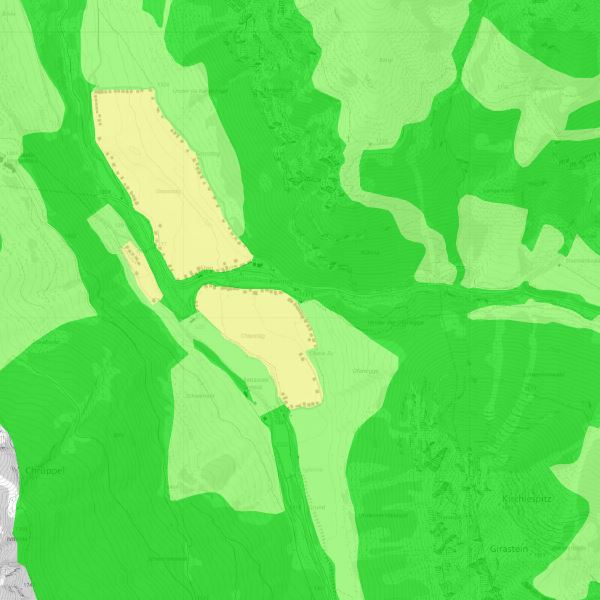
Pflanzenschutzgebiete
Plant protection areas
Das Liechtensteiner Alpengebiet ist ein Pflanzenschutzgebiet.
The Liechtenstein Alpine region is a plant conservation area.
Simple
-
Autre titreAltri nomi o acronimiAlternate titleAlternativtitel
-
Schutzgebiet für Pilze
Protected area for mushrooms
-
Date (Publication)Data (Pubblicazione)Date (Publication)Datum (Publikation)
- 2006-04-14
-
IdentifiantIdentificatoreIdentifierKennung
- https://metadata.geo.llv.li/085a5661-f405-4ea3-9342-ea2c3fbff74e
-
ButScopoPurposeZweck
-
Im Pflanzenschutzgebiet ist das Ausreissen, Ausgraben und Pflücken von Pflanzen verboten. (Verordnung zum Schutz der Gebirgspflanzen, LGBL. 1989 nr. 49)
The uprooting, digging and picking of plants is prohibited in the plant protection area. (Ordinance on the Protection of Mountain Plants, LGBL. 1989 no. 49)
-
ÉtatStatoStatusBearbeitungsstatus
-
TerminéCompletatoCompletedAbgeschlossen
Point de contact
Punto di contatto
Point of contact
Ansprechpartner
-
Heures de serviceOrario di servizioHours of serviceBetriebszeiten
-
8:00-11:30 und 13:30-17:00
-
Type de représentation spatialeTipo di rappresentazione spazialeSpatial representation typeRäumliche Darstellungsart
-
vecteurVettorialeVectorVektor
Résolution spatiale
Risoluzione spaziale
Spatial resolution
Räumliche Auflösung
-
Distance de résolutionDistanza di risoluzioneSpatial resolutionDistanz
- 1 m
-
Catégorie de thèmeCategoria ISOTopic categoryThematik
-
-
L EnvironnementL AmbienteL EnvironmentL Umwelt
-
S ÉlevageS AgricolturaS FarmingS Landwirtschaft
-
Étendue
Estensione
Extent
Ausdehnung
Étendue
Estensione
Extent
Ausdehnung
-
DescriptionDescrizioneDescriptionBeschreibung
-
Liechtenstein
Liechtenstein
Liechtenstein
Liechtenstein
))

-
Fréquence de mise à jourFrequenza di aggiornamentoMaintenance and update frequencyWartungsintervall
-
InconnueSconosciutoUnknownUnbekannt
Format de la ressource
Formato della risorsa
Resource format
Format der Ressource
-
TitreTitoloTitleTitel
-
INTERLIS 1 (ITF)
-
DateDataDateDatum
Format de la ressource
Formato della risorsa
Resource format
Format der Ressource
-
TitreTitoloTitleTitel
-
ESRI Shapefile (SHP)
-
DateDataDateDatum
- GEMET
-
-
préservation de la nature
conservazione della natura
nature conservation
-
réserve naturelle nationale
riserve nazionali
national reserve
-
champignon (ordre végétal)
funghi
fungus
-
champignon (comestible)
fungo
mushroom
-
- GEMET - INSPIRE themes, version 1.0
-
-
Sites protégés
Siti protetti
Protected sites
-
- geocat.ch
-
-
INSPIRE
INSPIRE
INSPIRE
-
- Räumlicher Anwendungsbereich
-
-
Local
Locali
Local
-
- GEMET
-
-
Landschaft
paysage
paesaggio
landscape
-
- geocat.ch
-
-
Natur
nature
natura
nature
-
Contraintes sur la ressource
Vincoli sulle risorse
Resource constraints
Ressourcenbeschränkungen
-
Limitation d'utilisationLimitazione d'usoUse limitationNutzungsbeschränkung
-
no Conditions apply
keine Einschränkungen
-
Contraintes d'accèsVincoli di accessoAccess constraintsZugriffsbeschränkungen
-
Autres restrictionsAltre restrizioniOther restrictionsAndere Beschränkungen
-
Contraintes d'utilisationVincoli d'usoUse constraintsNutzungseinschränkungen
-
Autres restrictionsAltre restrizioniOther restrictionsAndere Beschränkungen
-
Autres contraintesAltri vincoliOther constraintsAndere Einschränkungen
- No limitations to public accessNo limitations to public accessNo limitations to public accessNo limitations to public access
Contraintes sur la ressource
Vincoli sulle risorse
Resource constraints
Ressourcenbeschränkungen
-
Contraintes d'accèsVincoli di accessoAccess constraintsZugriffsbeschränkungen
-
Autres restrictionsAltre restrizioniOther restrictionsAndere Beschränkungen
-
Contraintes d'utilisationVincoli d'usoUse constraintsNutzungseinschränkungen
-
Autres restrictionsAltre restrizioniOther restrictionsAndere Beschränkungen
-
Autres contraintesAltri vincoliOther constraintsAndere Einschränkungen
- No conditions to access and useNo conditions to access and useNo conditions to access and useNo conditions to access and use
-
Autres contraintesAltri vincoliOther constraintsAndere Einschränkungen
- Opendata BY: Freie Nutzung. Quellenangabe ist Pflicht.Opendata BY: Utilisation libre. Obligation d’indiquer la source.Opendata BY: Libero utilizzo. Indicazione della fonte obbligatoria.Opendata BY: Open use. Must provide the source.
-
LangueLinguaLanguageSprache
- Deutsch
-
Encodage de caractèresCodifica dei caratteriCharacter encodingZeichenkodierung
-
Utf8UTF8UTF8Utf8
-
Catégorie de sous-thèmeCategoria di sottotemaSubtopic CategoryThematische Unterkategorien
-
L1 Protection de l’environnement, bruitL1 Protezione ambientale, RumoreL1 Environmental Protection, NoiseL1 Umweltschutz, Lärm
-
LangueLinguaLanguageSprache
- Deutsch
-
Livré avec jeu de donnéesFornito con set di datiIncluded with datasetMit Datensatz geliefert
- 0
-
TitreTitoloTitleTitel
-
Datenmodell Pflanzenschutzgebiete
-
Date (Publication)Data (Pubblicazione)Date (Publication)Datum (Publikation)
- 2006-03-14
-
Format de distributionFormato (codifica)Distribution formatAbgabeformat
-
-
INTERLIS 1 (ITF)
-
AutoCAD DXF (DXF)
-
ESRI Shapefile (SHP)
-
Point de contact
Punto di contatto
Point of contact
Ansprechpartner
-
Heures de serviceOrario di servizioHours of serviceBetriebszeiten
-
8:00-11:30 und 13:30-17:00
Options de transfert numérique
Opzioni di trasferimento digitale
Digital transfer options
Optionen für die digitale Übertragung
-
Ressource en ligneRisorsa onlineOnLine resourceOnline
-
Geodatenportal
Geodatenportal der Landesverwaltung
Options de transfert numérique
Opzioni di trasferimento digitale
Digital transfer options
Optionen für die digitale Übertragung
-
Ressource en ligneRisorsa onlineOnLine resourceOnline
-
li.au.nl_pflanzenschutzgebiet
OGC WMS Service der Liechtensteinen Landesverwaltung
-
NiveauLivelloHierarchy levelBezugsebene
-
Jeu de donnéesSet di datiDatasetDatenbestand
Rapport sur la qualité
Rapporto sulla qualità
Report
Qualitätsbericht
Result
Risultato
Result
Ergebnis
-
TitreTitoloTitleTitel
-
Verordnung (EG) Nr. 1089/2010 der Kommission vom 23. November 2010 zur Durchführung der Richtlinie 2007/2/EG des Europäischen Parlaments und des Rates hinsichtlich der Interoperabilität von Geodatensätzen und -diensten
-
Date (Publication)Data (Pubblicazione)Date (Publication)Datum (Publikation)
- 2010-12-08
-
ExplicationSpiegazioneExplanationErläuterung
-
nicht geprüft
-
Degré de conformitéGrado di conformitàPassKonformitätsgrad
- false
-
Généralités sur la provenanceInformazioni generali sulla provenienzaStatementErklärung
-
Erfassung auf der Grundlage der Grundstücksgrenzen und/oder Luftbilern
-
NiveauLivelloHierarchy levelBezugsebene
-
Jeu de donnéesSet di datiDatasetDatenbestand
-
Type d’objet géométriqueTipo di oggetto geometricoGeometric object typeTyp des geometrischen Objekts
-
PolygoneSuperficieSurfacesurface
-
Nombre d’objets géométriquesNumero di oggetti geometriciGeometric object countAnzahl geometrischer Objekte
- 50
-
Nom du système de référenceNome del sistema di riferimentoReference system identifierName des Referenzsystems
- http://www.opengis.net/def/crs/EPSG/0/21782
-
Nom du système de référenceNome del sistema di riferimentoReference system identifierName des Referenzsystems
- http://www.opengis.net/def/crs/EPSG/0/4936
Metadata
-
Identifiant des métadonnéesIdentificativo della schedaMetadata identifierIdentifikator des Metadatensatzes
- 085a5661-f405-4ea3-9342-ea2c3fbff74e
-
LangueLinguaLanguageSprache
- Deutsch
-
Encodage de caractèresCodifica dei caratteriCharacter encodingZeichenkodierung
-
Utf8UTF8UTF8Utf8
-
LangueLinguaLanguageSprache
- Français
-
Encodage de caractèresCodifica dei caratteriCharacter encodingZeichenkodierung
-
Utf8UTF8UTF8Utf8
-
LangueLinguaLanguageSprache
- Italiano
-
Encodage de caractèresCodifica dei caratteriCharacter encodingZeichenkodierung
-
Utf8UTF8UTF8Utf8
-
LangueLinguaLanguageSprache
- English
-
Encodage de caractèresCodifica dei caratteriCharacter encodingZeichenkodierung
-
Utf8UTF8UTF8Utf8
Point de contact
Punto di contatto
Point of contact
Ansprechpartner
-
Heures de serviceOrario di servizioHours of serviceBetriebszeiten
-
8:00-11:30 und 13:30-17:00
Type de ressource
Tipo di risorsa
Type of resource
Anwendungsbereich der Metadaten
-
Domaine d'application de la ressourceAmbito di applicazione della risorsaResource scopeDomäne der Ressourcenanwendung
-
Jeu de donnéesSet di datiDatasetDatenbestand
-
Informations de date (Création)Informazioni sulla data (Creazione)Date info (Creation)Datumsangaben (Erstellung)
- 2012-01-17T10:26:46Z
-
Informations de date (Révision)Informazioni sulla data (Revisione)Date info (Revision)Datumsangaben (Aktualisierung)
- 2026-04-13T09:31:47.433529Z
Norme des métadonnées
Standard dei metadati
Metadata standard
Metadatenstandard
-
TitreTitoloTitleTitel
-
eCH-0271