geocat.ch
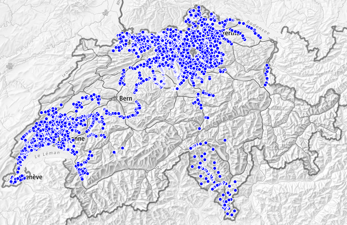
Height control points HFP2 (Cadastral surveying)
Survey points are the basis of all spatially referenced data. These control points (position control points (LFP) and the height control points (HFP)) are used for all surveying work that requires a reliable and precise determination. The term height control point refers to a point with a known height that is permanently marked with a bolt. Category 2 height control points (HFP2) are used to consolidate the point network and form the basis of the official cadastral survey. The cantons are responsible for the category 2 control points. The data are based on the KGK control point data service 2.0 model (KGKCGC_FPDS2_V1_1 data model, version 1.1).
Simple
- Alternate title
-
Height control points HFP2
- Date (Creation)
- 2010-02-09
- Date (Revision)
- 2023-03-15
- Identifier
- ch.swisstopo.fixpunkte-hfp2
Point of contact
GeoMeta
- Spatial representation type
- Vector
- Topic category
-
- B Location
Extent
Extent
- Description
-
Switzerland
))

- Maintenance and update frequency
- Daily
- Maintenance note
-
The HFP2 is the responsibility of the cantons. It is updated periodically or on an ongoing basis.
- geocat.ch
-
-
fixpoint
-
cadastral surveying
-
- geocat.ch
-
-
FSDI Federal Spatial Data Infrastructure
-
- Language
- Français
- Character encoding
- UTF8
- Language
- Deutsch
- Character encoding
- UTF8
- Language
- Italiano
- Character encoding
- UTF8
- Basic Geodata
- true
- Basic Geodata ID
-
54.2
- Basic Geodata Legal Level
- Federal
- Included with dataset
- 0
- Title
-
Modèle de données 2001 de la mensuration officielle
- Alternate title
-
MD.01-MO-CH / v.24
- Date (Publication)
- 2004-06-04
- Distribution format
-
-
INTERLIS 2 (XTF)
-
OGC Geopackage (GPKG)
-
ESRI Shapefile (SHP)
-
OGC Web Feature Service (WFS)
-
OGC Web Map Service (WMS)
-
Digital transfer options
- OnLine resource
-
Aperçu map.geo.admin.ch
Preview map.geo.admin.ch
Digital transfer options
- OnLine resource
-
Distribution des données
Digital transfer options
- OnLine resource
-
ch.swisstopo.fixpunkte-hfp2
WMS-FSDI service, layer "Height control points HFP2"
Digital transfer options
- OnLine resource
-
Le service de données sur les points fixes (FPDS)
Control point data service (FPDS)
Digital transfer options
- OnLine resource
-
Portail thématique
Digital transfer options
- OnLine resource
-
RESTful API de geo.admin.ch
RESTful API from geo.admin.ch
- Maintenance and update frequency
- As needed
Metadata
- Metadata identifier
- 06044c35-4164-41c6-a4df-297749c03227
- Language
- Français
- Character encoding
- UTF8
- Language
- Deutsch
- Character encoding
- UTF8
- Language
- Italiano
- Character encoding
- UTF8
- Language
- English
- Character encoding
- UTF8
- Language
- Rumantsch
- Character encoding
- UTF8
Point of contact
Type of resource
- Resource scope
- Dataset
- Metadata linkage
-
https://www.geocat.ch/geonetwork/srv/api/records/06044c35-4164-41c6-a4df-297749c03227
- Date info (Creation)
- 2012-10-16T16:30:11Z
- Date info (Revision)
- 2026-04-13T09:36:44.673182Z
Metadata standard
- Title
-
eCH-0271