 geocat.ch
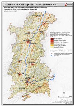
Population selon une grille kilométrique - 2011 PDF - Kilometer Bevölkerungdichtesnetz - 2011 PDF
Carte PDF de la population du Rhin Supérieur selon une grille kilométrique en 2011
PDF Karte mit Kilometerbevölkerungdichtesnetz im Oberrhein in 2011
Simple
- Date (Creation)
- 2019-04-08
- Identifier
- http://localhost:8080/geonetwork/srv/metadata/04124a9d-a7c5-46b3-8211-1930ca19a57d
- Presentation form
- Hardcopy map
- Status
- Completed
- Topic category
-
- M Society
Extent
Extent
N
S
E
W
))
- Maintenance and update frequency
- Unknown
- Keywords
-
-
Population;grille kilométrique;Kilometer;Bevölkerungdichte;netz;2011;PDF; Karte; carte
-
Resource constraints
- Use limitation
-
© OSM contributors - GeoRhena 2019 - ESTAT-GISCO@ec.europa.eu Data source population - Grid information: Eurostat, EFGS Office fédéral de la statistique, site web Statistique suisse 06/2019
- Access constraints
- Copyright
- Use constraints
- Copyright
- Language
- Français
- Distribution format
-
-
PDF
-
Digital transfer options
- OnLine resource
- Ouvrir la carte statique PDF / Die PDF Karte öffnen
Metadata
- Metadata identifier
- 04124a9d-a7c5-46b3-8211-1930ca19a57d
- Language
- Français
- Character encoding
- UTF8
Type of resource
- Resource scope
- staticMap
- Name
-
1
- Date info (Revision)
- 2019-08-02T06:43:08
Metadata standard
- Title
-
ISO 19115-3:2018
- Edition
-
1.0
)))