geocat.ch
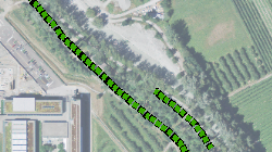
Plan directeur cantonal 2000: Allées de peupliers
Plan directeur cantonal 2000: Situation des allées de peupliers
Simple
- Alternate title
-
PDc 2000: Peupliers
- Date (Creation)
- 1998-01-01
- Identifier
- 71
- Purpose
-
Situer les allées de peupliers dans le cadre de la révision du plan directeur cantonal (2000)
- Status
- Obsolete
Custodian
- Spatial representation type
- Vector
Spatial resolution
Equivalent scale
- Denominator
- 10000
- Topic category
-
- L Environment
Extent
Extent
- Description
-
Canton of Valais (VS)
))

- Maintenance and update frequency
- Not planned
- Maintenance note
-
Données pas à jour
Resource format
- Title
-
ESRI Enterprise Geodatabase
- Date
- GEMET themes
-
-
natural areas, landscape, ecosystems
-
- GEMET
-
-
wind
-
nature conservation
-
alignment
-
- geocat.ch
-
-
protected natural zone
-
official geodata
-
Resource constraints
- Use limitation
-
Aucune
Resource constraints
- Access constraints
- Other restrictions
- Other constraints
-
Géodonnées accessibles au public (niveau A selon l'OGéo)
- Other constraints
-
Les conditions générales d'utilisation des géodonnées du Canton du Valais font foi ( https://www.vs.ch/fr/web/guest/information-legale).
- Language
- Français
- Character encoding
- UTF8
- Environment description
-
S:\Géodonnées VS\L2 Protection de la nature\Allées de peupliers.lyr
- Subtopic Category
- L2 Nature and Landscape Protection
- Basic Geodata
- true
- Basic Geodata ID
-
69>A.1
- Basic Geodata Legal Level
- Cantonal
- Basic Geodata Type
- basicGeodata
- Distribution format
-
-
ESRI Shapefile (SHP)
-
autres formats sur demande / andere Formate auf Anfrage
-
Distributor
- Statement
-
Etude du plan directeur cantonal
- Hierarchy level
- Dataset
- Description
-
Numérisation
- Geometric object type
- Curve
- Geometric object count
- 83
- Reference system identifier
- EPSG:2056/CH1903+_MN95
Metadata
- Metadata identifier
- 00759d9e-5993-49a5-a73f-36e3a41fd78d
- Language
- Français
- Character encoding
- UTF8
- Language
- Deutsch
- Character encoding
- UTF8
- Language
- Italiano
- Character encoding
- UTF8
- Language
- English
- Character encoding
- UTF8
- Language
- Rumantsch
- Character encoding
- UTF8
Distributor
Type of resource
- Resource scope
- Dataset
- Metadata linkage
-
https://www.geocat.ch/geonetwork/srv/api/records/00759d9e-5993-49a5-a73f-36e3a41fd78d
- Date info (Creation)
- 2016-10-25T14:55:17Z
- Date info (Revision)
- 2026-04-13T09:28:12.379147Z
Metadata standard
- Title
-
eCH-0271