 geocat.ch
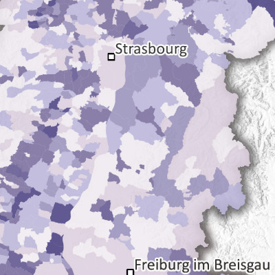
Emissions de gaz à effet de serre par habitant selon les communes et cantons dans le Rhin supérieur (2021)
Greenhouse gas emissions per capita by municipality and county in the Upper Rhine region (2021)
Treibhausgasemissionen pro Einwohner Gemeinden und Kantonen am Oberrhein (2021)
Produite dans le cadre du projet Interreg Rhin Supérieur Atmo-Rhena PLUS , cette carte représente les émissions de gaz à effet de serre par km² selon les communes et cantons sur le territoire du Rhin supérieur en 2021.
Limiter les émissions de gaz à effet de serre est le principal levier pour agir contre l’augmentation de la température moyenne de la planète provoquant les dérèglements climatiques. Les émissions de GES dans cet inventaire correspondent aux émissions « directes » d’un territoire, c’est-à-dire celles qui sont émises sur le territoire lui-même. Les émissions générées en dehors du territoire lors de la production, par exemple, de biens ou de services utilisés sur le territoire sont appelées émissions « indirectes » et ne sont pas prises en compte dans cet inventaire.
Dans cet inventaire, les trois principaux gaz à effet de serre du protocole de Kyoto sont pris en compte : le dioxyde de carbone CO2, le méthane CH4 et le protoxyde d’azote N2O. Les différentes émissions de gaz à effet de serre sont converties et additionnées en équivalents CO2 (ktCO2eq) à l'aide de leur Potentiel de Réchauffement Global (PRG). LE PRG utilisé ici est calculé selon la méthode du 5ème rapport du GIEC publié en 2013. Ces émissions totales de gaz à effet de serre sont également exprimées en équivalents CO2 avec l'unité ktCO2eq.
La carte des émissions de gaz à effet de serre pour le Rhin supérieur, tous secteurs confondus, laisse ressortir majoritairement des zones géographiques avec population et/ou trafic routier (villes, vallées des Vosges et de Forêt Noire, fossé rhénan), industrielles ou de production d’électricité.
La carte statique sous format PDF est disponible à l'échelle des communes (France et Allemagne) et des Cantons (Suisse). Les données sont accessibles en opendata uniquement à l'échelle des EPCI, Kreis et Cantons.
Produced as part of the Interreg Upper Rhine Atmo-Rhena PLUS project, this map shows greenhouse gas emissions per square kilometer by municipality and canton in the Upper Rhine region in 2021.
Limiting greenhouse gas emissions is the main lever for taking action against the rise in the planet's average temperature, which is causing climate change. The GHG emissions in this inventory correspond to the “direct” emissions of a territory, i.e., those emitted within the territory itself. Emissions generated outside the territory during the production, for example, of goods or services used within the territory are called “indirect” emissions and are not included in this inventory.
This inventory takes into account the three main greenhouse gases covered by the Kyoto Protocol: carbon dioxide (CO2), methane (CH4), and nitrous oxide (N2O). The various greenhouse gas emissions are converted and added together in CO2 equivalents (ktCO2eq) using their Global Warming Potential (GWP). The GWP used here is calculated according to the method set out in the IPCC's 5th Assessment Report published in 2013. These total greenhouse gas emissions are also expressed in CO2 equivalents using the unit ktCO2eq.
The map of greenhouse gas emissions for the Upper Rhine, all sectors combined, shows that most of the areas affected are populated and/or have heavy road traffic (cities, the Vosges and Black Forest valleys, the Rhine Rift Valley), are industrial, or are used for electricity generation.
The static map in PDF format is available at the municipal level (France and Germany) and at the canton level (Switzerland). The data is accessible as open data only at the EPCI, Kreis and canton levels.
Diese Karte wurde im Rahmen des Interreg-Projekts Oberrhein Atmo-Rhena PLUS erstellt und stellt die Treibhausgasemissionen pro km² nach Gemeinden und Kantonen im Oberrheingebiet im Jahr 2021 dar.
Die Begrenzung der Treibhausgasemissionen ist der wichtigste Hebel, um gegen die globale Erwärmung und somit den Klimawandel vorzugehen. Die THG-Emissionen in dieser Erhebung beziehen sich auf die „direkten“ Emissionen eines Gebietes. „Direkte“ Emissionen sind solche, die in dem Gebiet selbst emittiert werden. Emissionen, die außerhalb des Gebietes bei der Produktion von z.B. Gütern oder Leistungen entstehen, die innerhalb des Gebietes verwendet werden, bezeichnet man als „indirekte“ Emissionen und werden in dieser Erhebung nicht berücksichtigt.
In dieser Erhebung werden die drei wichtigsten Treibhausgase des Kyoto-Protokolls berücksichtigt: Kohlendioxid (CO2), Methan (CH4) und Distickstoffmonoxid (N2O - Lachgas). Die einzelnen Treibhausgasemissionen werden mit Hilfe ihrer Treibhausgaspotentiale (engl. Global Warming Potential - GWP) in CO2-Äquivalente (CO2eq) umgerechnet und summiert. Bei der Berechnung wird das GWP100 des 5. Sachstandsbericht des Intergovernmental Panel on Climate Change (IPPC) von 2013 verwendet. Diese gesamten Treibhausgasemissionen werden ebenfalls in CO2-Äquivalente mit der Einheit ktCO2eq angegeben.
Die Karte der Treibhausgasemissionen für den Oberrhein, über alle Sektoren summiert, zeigt, dass höhere Emissionen überwiegend in geografischen Gebieten mit starker Bevölkerung und/oder Straßenverkehr (Städte, Vogesen- und Schwarzwaldtäler, Oberrheingraben), Industrie- oder Stromerzeugung vorkommen.
Die statische Karte im PDF-Format ist auf Gemeindeebene (Frankreich und Deutschland) und Kantonsebene (Schweiz) verfügbar. Die Daten sind als Open Data nur auf Ebene der EPCI, Kreise und Kantone zugänglich.
Simple
-
Date (Creation)Datum (Erstellung)Date (Création)
- 2025-05-06
-
Date (Publication)Datum (Publikation)Date (Publication)
- 2025-11-06
-
IdentifierKennungIdentifiant
- AtmoRhenaPlus_GES_habitant
-
StatusBearbeitungsstatusÉtat
-
CompletedAbgeschlossenTerminé
Point of contact
Kontakt für die Ressource
Contact pour la ressource
-
mri:deliveryPointmri:deliveryPointmri:deliveryPoint
-
100, avenue d'Alsace
100, avenue d'Alsace
100, avenue d'Alsace
-
mri:citymri:citymri:city
-
COLMAR
-
mri:postalCodemri:postalCodemri:postalCode
-
68000
-
Countrymri:countrymri:country
-
FRANCE
FRANCE
FRANCE
-
mri:electronicMailAddressmri:electronicMailAddressmri:electronicMailAddress
Point of contact
Kontakt für die Ressource
Contact pour la ressource
-
mri:deliveryPointmri:deliveryPointmri:deliveryPoint
-
5, rue de Madrid
-
mri:citymri:citymri:city
-
Schiltigheim
-
mri:postalCodemri:postalCodemri:postalCode
-
67300
-
Countrymri:countrymri:country
-
France
-
mri:electronicMailAddressmri:electronicMailAddressmri:electronicMailAddress
Point of contact
Kontakt für die Ressource
Contact pour la ressource
Point of contact
Kontakt für die Ressource
Contact pour la ressource
-
mri:deliveryPointmri:deliveryPointmri:deliveryPoint
-
Rheinstrasse 29
-
mri:citymri:citymri:city
-
Liestal
-
mri:postalCodemri:postalCodemri:postalCode
-
4410
-
mri:electronicMailAddressmri:electronicMailAddressmri:electronicMailAddress
Point of contact
Kontakt für die Ressource
Contact pour la ressource
-
mri:deliveryPointmri:deliveryPointmri:deliveryPoint
-
Kaiser-Friedrich-Straße 7
-
mri:citymri:citymri:city
-
Mainz/Rhein
-
mri:postalCodemri:postalCodemri:postalCode
-
55116
-
mri:electronicMailAddressmri:electronicMailAddressmri:electronicMailAddress
Point of contact
Kontakt für die Ressource
Contact pour la ressource
-
mri:deliveryPointmri:deliveryPointmri:deliveryPoint
-
Bel'Oiseau 12, Case postale 69
-
mri:citymri:citymri:city
-
Saint-Ursanne
-
mri:postalCodemri:postalCodemri:postalCode
-
2882
-
mri:electronicMailAddressmri:electronicMailAddressmri:electronicMailAddress
Point of contact
Kontakt für die Ressource
Contact pour la ressource
-
Spatial representation typeRäumliche DarstellungsartType de représentation spatiale
-
VectorVektorvecteur
Spatial resolution
Räumliche Auflösung
Résolution spatiale
Equivalent scale
Vergleichsmassstab
Fraction représentative
-
DenominatorMassstabszahlDénominateur
- 50000
-
Topic categoryThematikCatégorie de thème
-
-
L EnvironmentL UmweltL Environnement
-
N HealthN GesundheitN Santé
-
Extent
Ausdehnung
Étendue
Extent
Ausdehnung
Étendue
Temporal extent
Zeitlicher Umfang
Étendue temporelle
-
Time periodZeitraumPériode
- 2020-01-01 2021-12-31
Extent
Ausdehnung
Étendue
Extent
Ausdehnung
Étendue
))
-
Maintenance and update frequencyWartungsintervallFréquence de mise à jour
-
Not plannedNicht geplantNon planifiée
-
ThemeThemaThème
-
-
Rhin Supérieur
Upper Rhine
Oberrhein
-
Transfrontalier
Crossborder
Grenzüberschreitend
-
- GEMET - Concepts, version 2.4
-
- airairLuft
- consommation d'électricitéelectricity consumptionElektrizitätsverbrauch
- pollution de l'airair pollutionLuftverunreinigung
- gaz à effet de serregreenhouse gasTreibhausgas
- altération climatiqueclimatic alterationKlimaentwicklung
- méthanemethaneMethan
- changement climatiqueclimatic changeKlimaänderung
- trafic routierroad trafficStraßenverkehr
- dioxyde de carbonecarbon dioxideKohlendioxid
- azotenitrogenStickstoff
- zone industrielleindustrial areaIndustriegebiet
Resource constraints
Ressourcenbeschränkungen
Contraintes sur la ressource
-
Use limitationNutzungsbeschränkungLimitation d'utilisation
-
Licence ODbL V1.0
CC-BY Licence ©OpenStreetMap contributors ©GeoRhena
CC-BY Lizenz ©OpenStreetMap contributors ©GeoRhena
Resource constraints
Ressourcenbeschränkungen
Contraintes sur la ressource
-
Access constraintsZugriffsbeschränkungenContraintes d'accès
-
Other restrictionsAndere BeschränkungenAutres restrictions
-
Use constraintsNutzungseinschränkungenContraintes d'utilisation
-
Other restrictionsAndere BeschränkungenAutres restrictions
-
Other constraintsAndere EinschränkungenAutres contraintes
-
Pas d'autre limitation
No other limitation
Keine andere Einschränkung
-
LanguageSpracheLangue
- Français
-
Character encodingZeichenkodierungEncodage de caractères
-
UTF8Utf8Utf8
-
LanguageSpracheLangue
- Deutsch
-
Character encodingZeichenkodierungEncodage de caractères
-
UTF8Utf8Utf8
-
LanguageSpracheLangue
- English
-
Character encodingZeichenkodierungEncodage de caractères
-
UTF8Utf8Utf8
Digital transfer options
Optionen für die digitale Übertragung
Options de transfert numérique
-
OnLine resourceOnlineRessource en ligne
-
0
Emissions de gaz à effet de serre (PRG 2013) par habitantGreenhouse gas emissions (GWP 2013) per capitaTreibhausgasemissionen (GWP 2013) pro Einwohner
Digital transfer options
Optionen für die digitale Übertragung
Options de transfert numérique
-
OnLine resourceOnlineRessource en ligne
-
Emissions de gaz à effet de serre (PRG 2013) par habitant
Greenhouse gas emissions (GWP 2013) per capita
Treibhausgasemissionen (GWP 2013) pro Einwohner
Digital transfer options
Optionen für die digitale Übertragung
Options de transfert numérique
-
OnLine resourceOnlineRessource en ligne
-
Portail Qualité de l’air du le Rhin supérieur
Upper Rhine Air Quality Portal
Luftqualitätsportal Oberrhein
Digital transfer options
Optionen für die digitale Übertragung
Options de transfert numérique
-
OnLine resourceOnlineRessource en ligne
-
Emissions de gaz à effet de serre (PRG 2013) par habitant
Greenhouse gas emissions (GWP 2013) per capita
Treibhausgasemissionen (GWP 2013) pro Einwohner
Digital transfer options
Optionen für die digitale Übertragung
Options de transfert numérique
-
OnLine resourceOnlineRessource en ligne
-
Tableau de bord Air-Climat-Energie du Rhin supérieur
Upper Rhine Air-Climate-Energy Dashboard
Dashboard Luft-Klima-Energie am Oberrhein
-
StatementErklärungGénéralités sur la provenance
-
Collecte des consommations finales d’énergie estimées pour la région Grand Est (ATMO Grand Est), le Bade-Wurtemberg (Landesanstalt für Umwelt Bade-Wurtemberg – LUBW et Statistisches Landesamt Baden-Württemberg - StaLa),les Cantons de Bâle Ville et Bâle Campagne (Lufthygienamt Beider Basel – LHA), la Rhénanie Palatinat (Landesamt für Umwelt Rheinland-Pfalz – LfU et Energieagentur Rheinland-Pfalz/Energieatlas - EA RLP) et le Canton du Jura (Office de l'environnement - ENV Jura). Les données des cantons du Jura, d'Argovie et de Soleure ont été regroupées par canton.
Collection of estimated final energy consumption for the Grand Est region (ATMO Grand Est), Baden-Württemberg (Landesanstalt für Umwelt Baden-Württemberg – LUBW and Statistisches Landesamt Baden-Württemberg - StaLa), the cantons of Basel-Stadt and Basel-Landschaft (Lufthygienamt Beider Basel – LHA), Rhineland-Palatinate (Landesamt für Umwelt Rheinland-Pfalz – LfU and Energieagentur Rheinland-Pfalz/Energieatlas - EA RLP) and the canton of Jura (Office de l'environnement - ENV Jura). Data from the cantons of Jura, Aargau, and Solothurn have been grouped by canton.
: Erhebung des abgeschätzten Endenergieverbrauchs für die Region Grand Est (ATMO Grand Est), den Baden-Württemberg (Landesanstalt für Umwelt Baden-Württemberg – LUBW und Statistisches Landesamt Baden-Württemberg - StaLa), den Kantonen Basel-Stadt und Basel-Landschaft (Lufthygienamt Beider Basel – LHA, die Rheinland-Pfalz (Landesamt für Umwelt Rheinland-Pfalz – LfU und Energieagentur Rheinland-Pfalz/Energieatlas - EA RLP), den Kanton Jura (Office de l'environnement - ENV Jura). Die Daten der Kantone Jura, Aargau und Solothurn wurden pro Kanton zusammengefasst.
-
Hierarchy levelBezugsebeneNiveau
-
staticMapstaticMapstaticMap
Metadata
-
Metadata identifierIdentifikator des MetadatensatzesIdentifiant des métadonnées
- 005c2ee1-0294-4702-b7f6-40fd7bd05618
-
LanguageSpracheLangue
- Français
-
Character encodingZeichenkodierungEncodage de caractères
-
UTF8Utf8Utf8
-
LanguageSpracheLangue
- English
-
Character encodingZeichenkodierungEncodage de caractères
-
UTF8Utf8Utf8
-
LanguageSpracheLangue
- Deutsch
-
Character encodingZeichenkodierungEncodage de caractères
-
UTF8Utf8Utf8
Contact
Kontaktstelle für Metadaten
Point de contact des métadonnées
-
mdb:deliveryPointmdb:deliveryPointmdb:deliveryPoint
-
100, avenue d'Alsace
100, avenue d'Alsace
100, avenue d'Alsace
-
mdb:citymdb:citymdb:city
-
COLMAR
-
mdb:postalCodemdb:postalCodemdb:postalCode
-
68000
-
mdb:countrymdb:countrymdb:country
-
FR
FR
FR
Type of resource
Anwendungsbereich der Metadaten
Type de ressource
-
Resource scopeDomäne der RessourcenanwendungDomaine d'application de la ressource
-
staticMapstaticMapstaticMap
-
Date info (Revision)Datumsangaben (Aktualisierung)Informations de date (Révision)
- 2025-11-06T10:41:56.268725Z
Metadata standard
Metadatenstandard
Norme des métadonnées
-
TitleTitelTitre
-
ISO 19115-3:2018
-
EditionAusgabeÉdition
-
1.0
)))